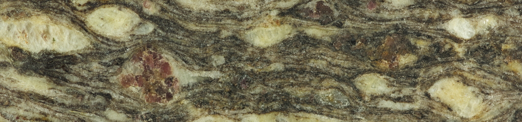
Nanga Parbat Gneiss -- an augen gneiss from the Nanga Parbat-Haramosh Massif near Chilas, northern Pakistan. Photo by Vince Cronin.
Introductory Structural Geology Home Page
This page functions as the course syllabus, and is not a contract. It is revised frequently throughout the semester.
Reload this page in your browser every time you visit this page to be certain that you are reading the most current course information
------------------------------------oOo------------------------------------
Baylor University syllabus statements, fall 2020, are incorporated by reference in this document, and are available for you to download and read HERE
The introductory course in structural geology introduces novice geoscientists to information that is essential to the professional practice of geology and geophysics, whether in academic research or as applied to meet societal need for resources, hazard recognition/mitigation, safe development of buildings and other infrastructure, or public planning/policy. This is an introduction to structural geology, in the same sense that what you see of an iceberg above water is an introduction to the entire iceberg.
Teacher-Contact Information
Teacher:
Professor Vince Cronin, Ph.D.
, email Vince_Cronin@baylor.edu
Other contact information is available on the course homepage in the Canvas
learning management system (LMS).
Ordered List of Course Topics
| Approx. Dates |
Weeks Allocated |
Topic and Link
to More Information |
eTextbook Chapter
|
Anticipated dates
for end-of-topic
quiz |
| August 24-26 |
0.5 |
Introduction
|
PSG&T Chapter 1
|
...to be announced |
| August 27-Sept 9 |
2 |
Force and stress
|
PSG&T Chapter 2
|
Sept 10-11 |
| Sept 10-23 |
2 |
Strain
|
PSG&T Chapter 6
|
Sept 24-25 |
| Sept 24-Oct 2 |
1.5 |
Rheology
|
PSG&T Chapter 10
|
Oct 3-4 |
| Oct 3-14 |
1.5 |
Friction
|
PSG&T Chapter 3
|
Oct 15-16 |
| Oct 15-18 |
0.5 |
Joints and Veins
|
PSG&T Chapter 4
|
Oct 19-20 |
| Oct 19-28 |
1.5 |
Faults
|
PSG&T Chapter 5
|
Oct 29-30 |
| Oct 29-Nov 6 |
1.5 |
Crystal Plasticity
|
PSG&T Chapter 7
|
...to be announced |
ov 7-8
| Nov 7-18 |
1.5 |
Folds
|
PSG&T Chapter 8
|
Nov 19-20 |
| Nov 19-25 |
1 |
Rock Deformation Fabrics
|
PSG&T Chapter 9
|
On the final exam |
Structural Geology Labs
The draft page associated with the labs for this course (held over from fall 2019) is accessible via https://croninprojects.org/Vince/Course/IntroStructGeol/3445-Lab-2020.html. It will be heavily revised in the coming days.
All labs, quizzes, assignments, and votes for the greatest Blasters single of all time should be submitted before the end of the day Wednesday, November 25, but must be submitted by the end of the day Sunday, November 29.
Primary course textbooks — lecture and lab
The
required
online textbook we will study during this course is by Ben van der Pluijm and Steve Marshak,
Processes in Structural Geology and Tectonics
(
psgt.earth.lsa.umich.edu
)
If you intend to be a geoscientist, it would make sense to buy
and keep
a paper copy of a good structural geology textbook, because structural geology is a very broad, important, and fundamental part of geoscience.
We might occasionally use material from Rick Allmendinger's lab book,
Modern Structural Practice (http://www.geo.cornell.edu/geology/faculty/RWA/structure-lab-manual/).
GeoEthics
Members of the Baylor Geosciences Department are expected to know and follow the
ethics code
of the
American Geophysical Union
, which is accessible along with other information via the AGU
Ethics Portal.
Expectations
I expect every novice geoscientist to work toward mastery of the material in this course.
That involves learning to understand and use geoscience terminology correctly, developing skills (making concept sketches, coding with a computer app like Excel or MatLab or Mathematica or..., being comfortable with basic counting statistics, embracing the assessment of uncertainty, contouring, making cross sections, finding references online, making structural contour maps, interpreting geologic maps, understanding basic GPS positioning technology, use of a Brunton compass, achieving clear written communication, etc.), and building background knowledge about how geological materials deform.
I expect every student in my course to treat every other student and me with respect, to be courteous, and to have an unwavering commitment to the truth.
I expect geoscientists to act with integrity in their professional/scientific lives and interpersonal interactions.
Learning the material in this course is your responsibility alone.
Through this webpage and its linked/referenced resources, you have plenty of opportunity to access good information about structural geology and related areas of geophysics and engineering. My job is simply to facilitate your learning.
Course grade
After the final exam, the work you have done in this course will be evaluated and a letter grade assigned that reflects the quality of that work. Your work will be considered as a portfolio.
Among the criteria that will be relevant to that grade decision are the following:
- Did you seem to stay engaged and participate in the course from beginning to end?
- Did you submit every assignment complete and on time?
- Was the work you submitted of high quality, both in terms of content and quality of presentation? For example, was your writing/printing clear and carefully done, or did it appear that you had written your submission while holding a dull pencil using the toes on your left foot as you were trying to avoid the swarm of angry fire ants that you had just stepped on? Clear and careful work is not only a necessity for someone else to understand your process and answers, but it is also a sign of respect.
- Did you meet expectations for academic, scientific, and personal integrity as manifested in the context of this course?
Some students who are not committed to learning and self development tend to view grades as entitlements, and so they assume they deserve a grade of "A" simply by registering for the course and not doing anything unforgivably bad during the semester. Actually, that qualifies a student for a grade of "F", although perhaps with a notation that they seem to be a nice person.
Earning a passing grade in this core course in structural geology requires your effort.
You will need to spend quality time working on this course every day. You will need to master the terminology with a sufficient understanding of the full meaning of each structural-geology term. If you are unwilling to devote that time to the course, you will not do well and will waste your time and money.
A "C" is not an uncommon grade in this course, and a "B" is a good grade. Relatively few grades of "A-" have been assigned by Professor Cronin over the past 3 decades of teaching this course, and the rarely-given grade of "A" means that he believes that the student has mastered the course material.
Dr. Cronin generally affords students the opportunity to provide a self-assessment before he assigns a final course grade.
Some useful resources
Background text files
-
Some comments on sample standard deviation and confidence intervals:
StdDevNotes.pdf
-
Summary of basic vector math:
VectorSummary30Aug2012.pdf
-
Summary of basic matrix math:
Matrices.pdf
-
Orthogonal coordinate transformations:
OrthogonalCoordTrans.pdf
-
Primer on infinitesimal strain analysis in 1, 2 and 3-D:
CroninProjects.org/Vince/Geodesy/GPS_Strain_Primer.doc
-
Algorithm for the GPS strain calculators (needs updating):
CroninProjects.org/Vince/Geodesy/gps_strain_triangle_algorithm.docx
-
Explanation of Excel GPS strain calculator output
CroninProjects.org/Vince/GPS-strain/explanation_gps_strain_calcula.docx
-
Focal mechanism primer for structural geologists:
https://CroninProjects.org/Vince/Course/IntroStructGeol/Focal_mechanism_primer_v4.pdf
-
Ken McClay's paper on
thrust-system terminology
(provided by Margaret Dooley)
Computer codes
GPS strain
-
GPS TriStrain Calculator in Excel:
https://d32ogoqmya1dw8.cloudfront.net/files/getsi/teaching_materials/gps_strain/gps_strain_calculator_excel.v3.xls
-
GPS TriStrain Calculator in Mathematica:
https://croninprojects.org/Vince/Geodesy/Calculators/gps-strain-calculator-mathematica.nb
-
GPS TriStrain Calculator in MatLab (zip file):
https://d32ogoqmya1dw8.cloudfront.net/files/getsi/teaching_materials/gps_strain/gps_strain_calculator_matlab.zip
Mathematica notebooks (codes)
To download the following
Mathematica
notebooks, either press
CONTROL
and click on the link (if you are smart enough to be using a Macintosh microcomputer) or right-click (if you still have to press
CONTROL ALT DELETE
to start your sad little Windows machine). Either way, you will need to have a copy of the
Mathematica
language loaded and ready to go on your computer in order to run these notebooks.
-
Seismo-Lineament Analysis Method (SLAM)
-
Mathematica
notebook "SLAM-code-2017.nb":
https://CroninProjects.org/Vince/SLAM/DVFZ-example/SLAM-code-2017.nb
-
Excel
spreadsheet "Input_EQ_datafile.xls":
https://CroninProjects.org/Vince/SLAM/DVFZ-example/Input_EQ_datafile.xls
-
Text (.dat) file "thinDVFZCrop.dat":
https://CroninProjects.org/Vince/SLAM/DVFZ-example/thinDVFZCrop.dat
-
Simple counting statistics
-
Mathematica
notebook "SimpleCountingStatistics.nb":
https://CroninProjects.org/Vince/Course/IntroStructGeol/SimpleCountingStatistics.nb
-
PDF printout of the SimpleCountingStatistics.nb notebook:
https://CroninProjects.org/Vince/Course/IntroStructGeol/SimpleCountingStatistics.pdf
-
Test datafile for the SimpleCountingStatistics.nb example:
https://CroninProjects.org/Vince/Course/IntroStructGeol/testData.xlsx
-
Mathematica
notebook "Eigen decomposition for 3D stress tensor":
EigenDecomposition3D.nb
-
The FisherStats code that acts upon geovector data (trend and plunge of a vector) is listed in a pdf file (
https://CroninProjects.org/Vince/Codes/FisherStats.pdf
) and is available in a
Mathematica
notebook (
https://CroninProjects.org/Vince/Codes/FisherStats.nb
). A sample dataset is available via
https://CroninProjects.org/Vince/Course/IntroStructGeol/rawInputData.xls
.
-
The FisherStats code that acts upon planar data data (RHR strike and dip angle) is listed in a pdf file (
https://CroninProjects.org/Vince/Codes/FisherStatsSD.pdf
) and is available in a
Mathematica
notebook (
https://CroninProjects.org/Vince/Codes/FisherStatsSD.nb
). A sample dataset is available via
https://CroninProjects.org/Vince/Course/IntroStructGeol/rawData.xls
.
Excel files
-
Simple counting statistics:
https://CroninProjects.org/Vince/Course/IntroStructGeol/SimpleCountingStatistics.xlsx
-
GPS TriStrain Calculator in Excel
CroninProjects.org/Vince/GPS-strain/gps_strain_calculator_excel.xls
CDF files
To run the following file, you will need to have a copy of the CDF Player from Wolfram:
https://www.wolfram.com/cdf-player/
Presentation files
-
Presentation file (pdf) about folds
FoldsLecture17s.pdf
(14.6 MB)
-
Cascadia GPS strain powerpoint
CroninProjects.org/Vince/GPS-strain/oregon_cascadia_post-exercise_.pptx
-
Basics of triangle strain analysis powerpoint
CroninProjects.org/Vince/GPS-strain/GPS_Triangle_Strain.ppt
Pedagogical files
-
Math prequiz:
MathPrequiz.pdf
-
Worksheet on basic vector math:
VectorWorksheet.pdf
-
PBO GPS worksheet
CroninProjects.org/Vince/GPS-strain/PBOWorksheet15.doc
-
Cascadia-Wasatch-San Andreas projects
CroninProjects.org/Vince/GPS-strain/gps_infinitesimal_strain_analy.pdf
-
Cascadia-Wasatch-San Andreas student exercises
CroninProjects.org/Vince/GPS-strain/gps_infinitesimal_strain_analy_1443091344.v2.docx
Animation/visualization files
-
Information about physical models and related videos:
CroninProjects.org/Vince/Course/IntroStructGeol/PhysModelAnimations.html
-
California Shake-Alert video
CroninProjects.org/Vince/GPS-strain/mp4_file_shakealert_earthquake.mp4
-
Cascadia-Tohoku earthquakes, video 1
CroninProjects.org/Vince/GPS-strain/animation_file_what_can.mp4
-
Cascadia-Tohoku earthquakes, video 2
CroninProjects.org/Vince/GPS-strain/Earthquake_Early_Warning_Pacific_Northwest.mp4
-
Animation-and-video homepage at UNAVCO:
https://www.unavco.org/education/outreach/animations/animations.html
-
Earthscope's geodetic component -- Plate Boundary Observatory (PBO) overview:
https://youtu.be/EPlCcRFpTuU
-
GPS Measures Deformation in Subduction Zones: Ocean/continent:
https://www.iris.edu/hq/inclass/animation/gps_measures_deformation_in_subduction_zones_oceancontinent
or, for direct download,
https://www.iris.edu/hq/inclass/downloads/download/95
-
GPS Measures Deformation in Subduction Zone: Island Arc Setting:
https://www.iris.edu/hq/inclass/animation/gps_measures_deformation_in_subduction_zone_island_arc_setting
or, for direct download,
https://www.iris.edu/hq/inclass/downloads/download/96
-
GPS Records Variable Deformation across a Subduction Zone:
https://www.iris.edu/hq/inclass/animation/gps_records_variable_deformation_across_a_subduction_zone
or, for direct download,
https://www.iris.edu/hq/inclass/downloads/download/92
-
What can GPS tell us about future earthquakes?
https://www.iris.edu/hq/inclass/animation/pacific_northwest_vs_japan_similar_tectonic_settings
or, for a direct download,
https://www.unavco.org/education/outreach/animations/Japan-vs-PacificNW_What-can-GPS-tell-us.mp4
-
Sendai/Tohoku-oki earthquake displacements using 1 Hz data (by Ronni Grapenthin):
https://youtu.be/rMhhyb6Yy94
-
GPS as an essential component of Cascadia earthquake early warning:
https://www.iris.edu/hq/inclass/animation/earthquake_early_warning_pacific_northwest_subduction_zone
or, for a direct download,
https://www.unavco.org/education/outreach/animations/GPSEarthquakeEarlyWarning.mp4
-
ShakeAlert: Earthquake Early Warning System for Napa earthquake 2014:
https://www.iris.edu/hq/inclass/animation/shakealert_earthquake_early_warning_system
or, for direct download,
https://www.iris.edu/hq/inclass/downloads/download/407
-
Basin & Range: GPS measures extension:
https://www.iris.edu/hq/inclass/animation/basin__range_gps_measures_extension
or, for direct download,
https://www.iris.edu/hq/inclass/downloads/download/193
-
Tectonics & Earthquakes of the Himalaya:
https://www.iris.edu/hq/inclass/animation/tectonics__earthquakes_of_the_himalaya
or, for direct download,
https://www.iris.edu/hq/inclass/downloads/download/466
-
Volcano Monitoring: Measuring Deformation and Tilt with GPS:
https://www.iris.edu/hq/inclass/animation/volcano_monitoring_measuring_deformation_and_tilt_with_gps
or, for direct download,
https://www.iris.edu/hq/inclass/downloads/download/138
-
Glaciers are retreating. How can we measure the full ice loss?
https://youtu.be/FVm3rZZs49s?list=PLzmugeDoplFOot41MIBBZiLYBCB0M-p1P
-
Plate tectonics 540Ma to the modern world, from Chris Scotese:
https://youtu.be/g_iEWvtKcuQ
-
Plate tectonics 240Ma to 250 million years in the future, from Chris Scotese:
https://youtu.be/uLahVJNnoZ4
Web resources
-
Online resources for
Fossen (2010)
-
Online declination calculator, maintained by the National Geophysical Data Center of the National Oceanic and Atmospheric Administration:
www.ngdc.noaa.gov/geomag-web/
-
PBO network map
www.unavco.org/instrumentation/networks/status/pbo
-
UNR Magnet and other GPS stations map
geodesy.unr.edu/NGLStationPages/gpsnetmap/GPSNetMap.html
-
"Aftermath of the 2011 Tohoku earthquake and tsunami" Wikipedia article,
https://en.wikipedia.org/wiki/Aftermath_of_the_2011_Tohoku_earthquake_and_tsunami#Economic_impact
-
Information and data from the EarthScope Plate Boundary Observatory (PBO) is available online via
https://pbo.unavco.org
-
Another way to access PBO data and to see velocity vectors is via the UNAVCO Velocity Viewer (
https://www.unavco.org/software/visualization/GPS-Velocity-Viewer/GPS-Velocity-Viewer.html
)
-
Information about the geodetic reference frames can be found at
https://www.unavco.org/software/visualization/GPS-Velocity-Viewer/GPS-Velocity-Viewer-frames.html
-
Information about UNAVCO is available online via
https://www.unavco.org/
-
The full public GPS/GNSS data holdings of UNAVCO are available via their Data Archive Interface Version 2 (
https://www.unavco.org/data/gps-gnss/data-access-methods/dai2/app/dai2.html#
- Old structure labs: https://CroninProjects.org/Vince/Course/IntroStructGeol/OldStructLabs-index.html
-->
References
- Bernknopf, R.L., Brookshire, D.S., Soller, D.R., McKee, M.J., Sutter, J.F., Matti, J.C., and Campbell, R.H., 1993, Societal value of geologic maps: U.S. Geological Survey Circular 1111, 53 pages, accessible via https://pubs.er.usgs.gov/publication/cir1111.
-
Billingsley, G.H., 2000, Geologic map of the Grand Canyon 30' x 60' Quadrangle, Coconino and Mohave Counties, northwestern Arizona: USGS Geologic Investigations Series I-2688, 1:100,000 scale, accessible online via
pubs.usgs.gov/imap/i-2688/i-2688.pdf
and
pubs.usgs.gov/imap/i-2688/i-2688_pamphlet.pdf
.
- Davis, G.H., Reynolds, S.J., and Kluth, C.F., 2011, Structural geology of rocks and regions [3rd edition]: New York, Wiley, 864 pages.
-
Federal Geographic Data Committee, 2006, FGDC digital cartographic standard for geologic map symbolization: Reston, VA, Federal Geographic Data Committee Document Number FGDC-STD-013-2006, 290 pages, 2 plates; accessible via
ngmdb.usgs.gov/fgdc_gds/
or
ngmdb.usgs.gov/fgdc_gds/geolsymstd/fgdc-geolsym-all.pdf
.
- Fossen, H., 2016, Structural geology [2nd edition]: Cambridge University Press, 524 pages.
- Johnson, J.K., and Reynolds, S.J., 2005, Concept sketches — using student- and instructor-generated, annotated sketches for learning, teaching, and assessment in geology courses: Journal of Geoscience Education, v. 53, no. 1, p. 85-95.
- Lisle, R.J., 2003, Geological structures and maps [3rd edition]: Oxford, Butterworth-Heinemann, 120 pages.
- Neuendorf, K.K.E., Mehl, J.P., Jr., and Jackson, J.A., 2011, Glossary of Geology [5th edition, revised]: Alexandria, Virginia, American Geosciences Institute, 800 pages.
- Reusser, L.J., Corbett, L.B., and Bierman, P.R., 2012, Incorporating concept sketching into teaching undergraduate geomorphology: Journal of Geoscience Education, v. 60, p. 3-9.
- Spencer, E.W., 2006, Geologic maps — A practical guide to the preparation and interpretation of geologic maps [2nd edition]: Waveland Press, 145 pages.
- van der Pluijm, B.A., and Marshak, S., 2003, Earth structure [2nd edition]: New York, W.W. Norton & Co., 672 pages.
A must-read article
New York Times Magazine article "
Losing Earth: The Decade We Almost Stopped Climate Change
" by Nathaniel Rich, with photos and videos by George Steinmetz.
If you have any questions or comments about this site or its contents, drop an email to the humble
webmaster
.
All of the original content of this website is © 2019 by Vincent S. Cronin