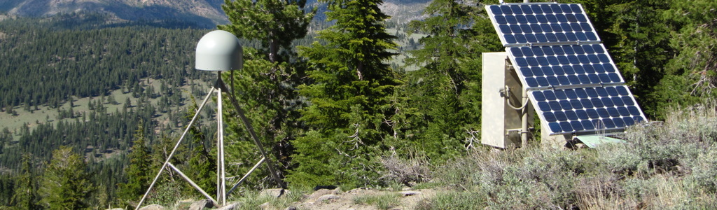
Plate Boundary Observatory Site P150 on Martis Peak, California. Data from this site are available via UNAVCO. Photo by Vince Cronin.
Documents for the GETSI workshop at the Earth Educators' Rendezvous, 2018
Website for this GETSI module
GPS, Strain, and Earthquakes
https://serc.carleton.edu/getsi/teaching_materials/gps_strain/index.html
NOTE that the most current module materials can be downloaded via the link provided above. Some of the files linked below were derived from this resource set on or about 5 July 2018.
UNAVCO is "a non-profit university-governed consortium [that] facilitates geoscience research and education using geodesy." The public resources of UNAVCO are available via http://www.unavco.org, including data, software, and the many products of its education and outreach efforts. More information about UNAVCO is available at http://www.unavco.org/about/about.html.
Documents used or referenced during the workshop (in approximate order of use)
Introduction and motivation: http://croninprojects.org/GETSI-EER2018/1.Motivation-Intro-v1-lowres.pdf (lowres pdf, 27.6 MB) [highres pdf, 175.4 MB] [JPEG images, 27.8 MB total] [Keynote original 158.4 MB]
Overview of module: http://croninprojects.org/GETSI-EER2018/2.0.Overview-GPS-strain-module-lowres.pdf (lowres pdf, 6.9 MB) [highres pdf, 10.1 MB] [JPEG images, 7 MB total] [Keynote original 9.7 MB]
GPS/GNSS Basics: http://croninprojects.org/GETSI-EER2018/3.introduction_gps_presentation.v11.pdf (pdf, 34.4 MB) [PowerPoint original 32.2 MB]
- GPS Spotlight website hosted by UNAVCO with great background information about GPS and the many ways that it is being used for scientific investigations: https://spotlight.unavco.org
GPS strain analysis (lowres pdf, 13.7 MB) [highres pdf, 33.7 MB] [JPEG images, 21 MB total] [Keynote original 40.9 MB]
- How to find PBO GPS data: https://d32ogoqmya1dw8.cloudfront.net/files/getsi/teaching_materials/gps_strain/finding_gps_data_oregon.v6.docx
- Cascadia example worksheets: http://croninprojects.org/GETSI-EER2018/Cascadia-Example.pdf (.pdf file 2 MB) [Microsoft Word .docx file, 2 MB]
- Interactive PBO GPS network map: http://www.unavco.org/instrumentation/networks/status/pbo/gps
- Overview PBO station page for site P395: https://www.unavco.org/instrumentation/networks/status/pbo/overview/P395
- Overview PBO station page for site P396: https://www.unavco.org/instrumentation/networks/status/pbo/overview/P395
- Overview PBO station page for site P404: https://www.unavco.org/instrumentation/networks/status/pbo/overview/P404
- Rogers, G., and Dragert, H., 2003, Episodic tremor and slip on the Cascadia Subduction Zone -- the chatter of silent slip: Science, v. 300, Issue 5627, p, 1942-1943, DOI: 10.1126/science.1084783
- GPS strain Calculators
- How to interpret the strain calculator output: https://d32ogoqmya1dw8.cloudfront.net/files/getsi/teaching_materials/gps_strain/explanation_gps_strain_calculator.v3.pdf (.pdf file) [Microsoft Word .docx file]
- Strain ellipse visualization tool (https://d32ogoqmya1dw8.cloudfront.net/files/getsi/teaching_materials/gps_strain/strain_ellipse_visualization_t.zip), which requires a free copy of Wolfram CDF Player (http://www.wolfram.com/cdf-player/)
- Background information
Cascadia strain example: http://croninprojects.org/GETSI-EER2018/5.oregon_cascadia_post-exercise_.v3.pdf (pdf, 1.8 MB) [PowerPoint original 1.9 MB]
Graphic summary of the triangle-strain analysis: http://croninprojects.org/GETSI-EER2018/6.gps_infinitesimal_strain_analy.v2.pdf (pdf, 3.1 MB) [PowerPoint original 3.1 MB]
A relevant physical model
Your turn to do an analysis: http://croninprojects.org/GETSI-EER2018/9.Your-Turn-lowres.pdf (lowres pdf, 2.4 MB) [highres pdf, 5.3 MB] [JPEG images, 3.1 MB total] [Keynote original 5.9 MB]
Additional documents related to this module used in Vince Cronin's Intro to Structural Geology course
Relevant UNAVCO/IRIS animations and videos
- UNAVCO videos on U-Tube: https://www.youtube.com/user/unavcovideos
- Animation-and-video homepage at UNAVCO: https://www.unavco.org/education/outreach/animations/animations.html
- Earthscope's geodetic component -- Plate Boundary Observatory (PBO) overview: https://youtu.be/EPlCcRFpTuU
- GPS Measures Deformation in Subduction Zones: Ocean/continent: https://www.iris.edu/hq/inclass/animation/gps_measures_deformation_in_subduction_zones_oceancontinent or, for direct download, https://www.iris.edu/hq/inclass/downloads/download/95
- GPS Measures Deformation in Subduction Zone: Island Arc Setting: https://www.iris.edu/hq/inclass/animation/gps_measures_deformation_in_subduction_zone_island_arc_setting or, for direct download, https://www.iris.edu/hq/inclass/downloads/download/96
- GPS Records Variable Deformation across a Subduction Zone: https://www.iris.edu/hq/inclass/animation/gps_records_variable_deformation_across_a_subduction_zone or, for direct download, https://www.iris.edu/hq/inclass/downloads/download/92
- What can GPS tell us about future earthquakes? https://www.iris.edu/hq/inclass/animation/pacific_northwest_vs_japan_similar_tectonic_settings or, for a direct download, https://www.unavco.org/education/outreach/animations/Japan-vs-PacificNW_What-can-GPS-tell-us.mp4
- Sendai/Tohoku-oki earthquake displacements using 1 Hz data (by Ronni Grapenthin): https://youtu.be/rMhhyb6Yy94
- GPS as an essential component of Cascadia earthquake early warning: https://www.iris.edu/hq/inclass/animation/earthquake_early_warning_pacific_northwest_subduction_zone or, for a direct download, https://www.unavco.org/education/outreach/animations/GPSEarthquakeEarlyWarning.mp4
- ShakeAlert: Earthquake Early Warning System for Napa earthquake 2014: https://www.iris.edu/hq/inclass/animation/shakealert_earthquake_early_warning_system or, for direct download, https://www.iris.edu/hq/inclass/downloads/download/407
- Basin & Range: GPS measures extension: https://www.iris.edu/hq/inclass/animation/basin__range_gps_measures_extension or, for direct download, https://www.iris.edu/hq/inclass/downloads/download/193
- Tectonics & Earthquakes of the Himalaya: https://www.iris.edu/hq/inclass/animation/tectonics__earthquakes_of_the_himalaya or, for direct download, https://www.iris.edu/hq/inclass/downloads/download/466
- Volcano Monitoring: Measuring Deformation and Tilt with GPS: https://www.iris.edu/hq/inclass/animation/volcano_monitoring_measuring_deformation_and_tilt_with_gps or, for direct download, https://www.iris.edu/hq/inclass/downloads/download/138
- Glaciers are retreating. How can we measure the full ice loss? https://youtu.be/FVm3rZZs49s?list=PLzmugeDoplFOot41MIBBZiLYBCB0M-p1P
- Plate tectonics 540Ma to the modern world, from Chris Scotese: https://youtu.be/g_iEWvtKcuQ
- Plate tectonics 240Ma to 250 million years in the future, from Chris Scotese: https://youtu.be/uLahVJNnoZ4
Ackowledgments
This GETSI module would not exist without the efforts of many people at UNAVCO and elsewhere. The UNAVCO Community provided the collaborative environment in which we could create resources to facilitate student learning about an important topic that was not represented in the undergraduate geoscience curriculum. The book Structural Geology Algorithms by Rick Allmendinger, Nestor Cardozo and Don Fisher (2012, Cambridge University Press) provided a clear explanation of relevant topics -- it served as an initial ramp at the base of the learning curve. Bill Hammond and Corné Kreemer of the University of Nevada-Reno have been unfailingly generous with their time, serving as our geodetic experts. Phil Resor (Wesleyan University) and I have broadly similar backgrounds as structural geologists, but Phil has brought a different level of intelligence, energy and creativity to the project. He is the author of the MatLab resources and (with input from Hammond) the lead author of the Napa Earthquake unit. Shelly Olds (UNAVCO) encouraged the initial development of these resources, and Beth Pratt-Sitaula (also UNAVCO) has been the driving force behind the reformulation of the first-gen resources into a coherent GETSI module. Donna Charlevoix and Meghan Miller have provided generous institutional support from UNAVCO. Nancy West helped us to keep the cognitive level of the resources developed for this module within the range of average undergraduate geoscience students.
— Vince Cronin
If you have any questions or comments about this site or its contents, drop an email to the humble webmaster.