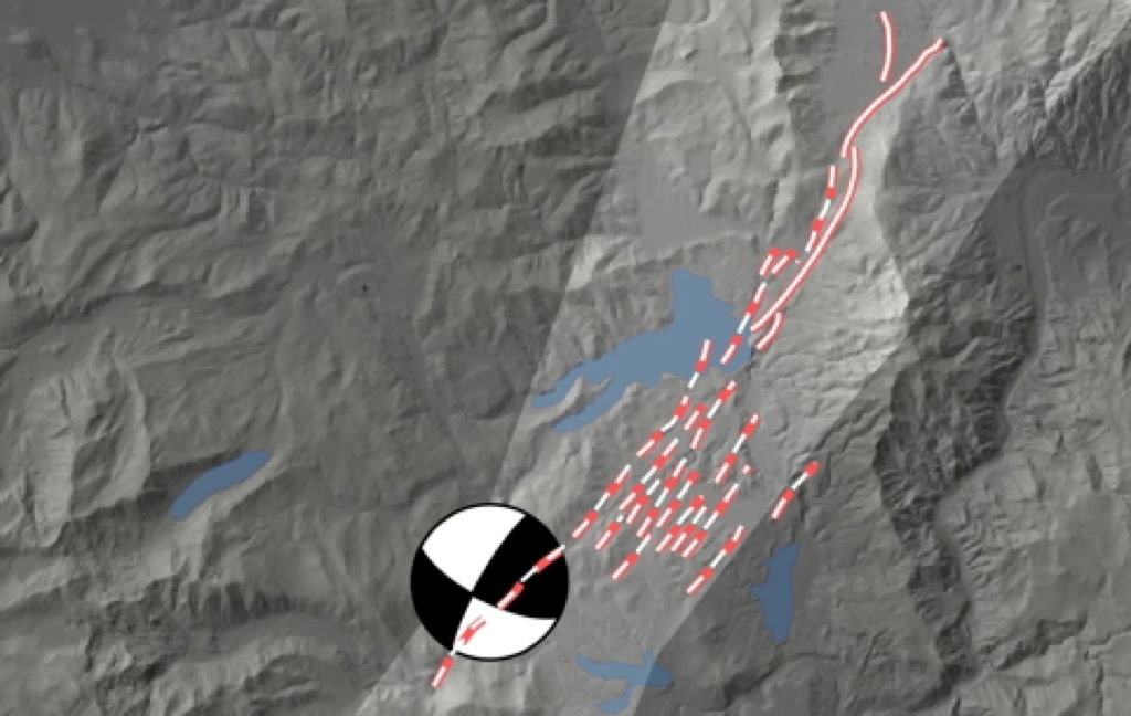
Seismo-lineament along the Dog Valley Fault Zone near Truckee, California.
Resources for the Seismo-Lineament Analysis Method (SLAM)
The seismo-lineament analysis method is a tool to spatially correlate a shallow-focus earthquake to the surface trace of the fault that generated it. SLAM is the intellectual property and work product of Vince Cronin, and has been developed with assistance from Catherine Hobart, Brandon Rasaka, Victoria Worrell, Jeremy Ashburn, Luke Pajer, Brian Bayliss, Chris Breed, Bruce Byars, Ryan Campbell, David Cleveland, Jon Cook, Kelly Cronin, Jordan Dickinson, Daniel Lancaster, Ryan Lindsay, Mark Millard, Shane Prochnow, Tyler Reed, Stephen Secrest, Lauren Seidman Robinson, Keith Sverdrup and Lisa Zygo, with funds from AAPG, Association of Environmental and Engineering Geologists (AEG), Baylor University, Colorado Scientific Society, Ellis Exploration, Ft. Worth Geological Society, Geological Society of America (GSA), Gulf Coast Association of Geological Societies (GCAGS), Samson Resources, Roy Shlemon Scholarship Fund, Sigma Xi, and SIPES.
Full papers describing SLAM
Cronin, V.S., 2014, Seismo-Lineament Analysis Method (SLAM), using earthquake focal mechanisms to help
recognize seismogenic faults,
in
Grutzner, C., Choi, J-H., Edwards, P., and Kim, Y-.S., [editors],
Proceeding of the 5th International INQUA Meeting on Paleoseismology, Active Tectonics and Archeoseismology
, 21-27 September 2014, p. 28-31, ISBN 9791195344109 93450; available via
https://CroninProjects.org/Vince/SLAM/CroninINQUA_PATA14.pdf
Cronin, V.S., Millard, M., Seidman, L, and Bayliss, B., 2008, The Seismo-Lineament Analysis Method (SLAM) -- A Reconnaissance Tool to Help Find Seismogenic Faults: Environmental and Engineering Geology, v. 14, no. 3, p. 199-219. Available via GeoScience World at
https://eeg.geoscienceworld.org/cgi/content/abstract/14/3/199
If you do not have access to the paper online, please contact Vince Cronin directly for a copy: Vince_Cronin@baylor.edu
Typical SLAM workflow
- Acquire earthquake data
- Acquire DEM data. A suitable DEM dataset is a flat file (text file; e.g., and Arc ASCII GRID file) with a 6-record header and a rectangular matrix of elevation data.
— Video about getting a DEM and hillshade map from OpenTopography.org: https://youtu.be/hcRqC2bYS14
- Use the SLAM code to define the seismo-lineament boundaries
- Conduct the structural-geomorphic analysis of the area within the seismo-lineament boundaries, using hillshade maps with low illumination angle in directions nearly perpendicular to the strike of the fault-plane solution. Use the highest-resolution DEMs for this purpose.
- Consult all available fault maps of the area, created by reliable sources, to evaluate whether the earthquake occurred on a known fault. Start with
— the Quaternary Fault and Fold Database of the United States at https://www.usgs.gov/natural-hazards/earthquake-hazards/faults or https://usgs.maps.arcgis.com/apps/webappviewer/index.html?id=5a6038b3a1684561a9b0aadf88412fcf, and
— the National Geologic Map Database at https://ngmdb.usgs.gov/ngmdb/ngmdb_home.html
- Are there other earthquakes with focal mechanisms/moment tensors in the catalog that might have seismo-lineaments that overlap with your subject earthquake?
- Are there other earthquakes that might be related to the subject earthquake — foreshocks and aftershocks, for example? If so, consider doing a 3-D planar regression to find a best-fit plane through the hypocenter point cloud.
- Develop hypotheses for the location of possible fault traces that might correlate with the subject earthquake.
- Design a field study to test those hypotheses. For example, go to the area, look along any lineaments identified in the structural-geomorphic study to find evidence of recent faulting. In particular, look for shear surfaces whose striae are approximately parallel to the slip vector of the fault-plane solution. If there are no suitable outcrops, consider EM and resistivity surveys across suspected fault traces to evaluate whether there appears to be subsurface evidence of faulting. Then (safely) trench suspected fault traces.
- Interpret the results. Be mindful not to extend beyond a reasonable interpretation of the data.
Current SLAM codes
Note. These are research codes that are the intellectual property of Vince Cronin. You can use them, but you cannot adapt them for sale as a proprietary commercial code.
Current versions of the SLAM code in Mathematica
A larger, higher-res version of the DEM file is available at DogValleyFull27.dat (71.3 MB)
Other potentially useful codes
None of the Mathematica codes written by Cronin are particularly user-friendly — they are research codes.
Some SLAM Thesis References
Ashburn, Jeremy, 2015,
Investigation of a lineament that might mark the ground-surface trace of the Dog Valley fault, Truckee area, northern California
: B.S. thesis, Baylor University, accessible via
https://CroninProjects.org/Vince/AshburnBSThesis2015.pdf
Bayliss, Brian, 2007,
Test of a method for recognizing unmapped seismogenic faults
: M.S. thesis, Baylor University, accessible via
https://hdl.handle.net/2104/5035
Dickinson, Jordan, 2015,
A seismo-lineament study of magnitude 3.3-5.3 earthquakes near Trinidad, Colorado
: B.S. thesis, Baylor University, accessible via
https://CroninProjects.org/Dickinson/Dickinson.pdf
Hobart, Catherine, 2021, Selecting locations for future geophysical surveys in search of the Dog Valley fault using earthquake, LiDAR, and GPS data: M.S. thesis, Baylor University, accessible via https://baylor-ir.tdl.org/handle/2104/11697
Hobart, Catherine, 2021, Selecting locations for future geophysical surveys in search of the Dog Valley fault using earthquake, LiDAR, and GPS data: M.S. thesis, Baylor University, accessible via https://baylor-ir.tdl.org/handle/2104/11697
Lancaster, Daniel, 2011,
Correlation of earthquakes with seismogenic faults along the Northern Arizona Seismic Belt, southwestern margin of the Colorado Plateau
: M.S. thesis, Baylor University, accessible via
https://hdl.handle.net/2104/8228
Lindsay, Ryan, 2012,
Seismo-lineament analysis of selected earthquakes in the Tahoe-Truckee area, California and Nevada
: M.S. thesis, Baylor University, accessible via
https://hdl.handle.net/2104/8441
Millard, Mark, 2007,
Linking onshore and offshore data to find seismogenic faults along the Eastern Malibu coastline
: M.S. thesis, Baylor University, accessible via
https://hdl.handle.net/2104/5109
Rasaka, Brandon, 2016,
Correlation of selected earthquakes with seismogenic faults, central Oklahoma
: M.S. thesis, Baylor University, accessible via
https://CroninProjects.org/Rasaka/Rasaka-MS-Thesis-2016.pdf
Reed, Tyler, 2014,
Spatial correlation of earthquakes with two known and two suspected seismogenic faults, north Tahoe-Truckee area, California: M.S. thesis, Baylor University, accessible via
https://hdl.handle.net/2104/9097
Seidman, Lauren, 2007,
Seismo-lineament analysis of the Malibu Beach quadrangle, Southern California
: M.S. thesis, Baylor University, accessible via
https://hdl.handle.net/2104/5108
Strasser, Matthew, 2017, Spatial Correlation of Selected Earthquakes with the Dog Valley Fault in Northern California using LiDAR and GPS Data: M.S. thesis, Baylor University, accessible via https://baylor-ir.tdl.org/handle/2104/10134
Worrell, Victoria, 2014, The Seismo-Lineament Analysis Method (SLAM) applied to the South Napa Earthquake and antecedent events: M.S. thesis, Baylor University, accessible via
Download from https://hdl.handle.net/2104/9796
Some documents from past SLAM presentations
An Adobe Acrobat PDF file of Vince Cronin's presentation at the INQUA PATA meeting in Busan, South Korea, is accessible via
https://CroninProjects.org/Vince/SLAM/Cronin_PATA14.pdf
, and provides a visual introduction to SLAM.
An Adobe Acrobat PDF file of the oral presentation about SLAM at the Latin American Geological Congress in Medellin, Colombia, on August 31, 2011, is accessible via
https://CroninProjects.org/Vince/SLAM/Cronin31Aug2011.pdf
(~1.2 MB)
A poster describing tests of SLAM that has been presented at the IRIS workshop "Geophysical Hazards and Plate Boundary Processes in Central America, Mexico and the Caribbean" in October 2010 is accessible via
https://CroninProjects.org/Vince/posters/CroninGHMAW2010r.pdf
(~8 Mb).
The PowerPoint file of the
Cronin and others presentation
"Finding probable seismogenic faults using EarthScope data and SLAM" at the AEG meeting in South Lake Tahoe (2009) is accessible via
https://CroninProjects.org/Vince/tahoe/CroninEtAl_AEG09.ppt
. The first half is an overview of EarthScope, and an example of a preliminary application of SLAM in the Lake Tahoe area is at the end of the presentation.
SLAM Bibliography (in approximate superposed chronological order; probably incomplete)
- Hobart, Catherine, Dunbar, J., White, J., and Cronin, V.S., 2020, A preliminary look at whether activity on the Polaris Fault could increase the potential for activity on the Dog Valley Fault near Truckee, California: Geological Society of America, Abstracts with Programs, v. 52, no. 6, doi: 10.1130/abs/2020AM-356509, accessible via https://gsa.confex.com/gsa/2020AM/meetingapp.cgi/Paper/356509
- Hobart, C., Cronin, V.S., White, J., and Dunbar, J., 2020, Dog Valley fault as a potential threat to Stampede, Prosser Creek, and Boca Dams: Association of Engineering Geologists Annual Meeting, accessible via https://aeg.mclms.net/en/package/1878/course/4312/view#course-content
-
Strasser, M., and Cronin, V.S., 2017, Search for the Dog Valley Fault -- Cause of the M 6 Truckee Earthquake Near the Stampede, Boca, and Prosser Creek Dams: AEG News, 60th Annual Meeting Program with Abstracts, p. 84, accessible via
https://docs.wixstatic.com/ugd/b33307_ae02631d54f943dc95c8d22c491edaa1.pdf
-
Cronin, V.S., and Strasser, M.P., 2017, Proximity of the Seismogenic Dog Valley Fault to Stampede and Proser Creek Dams Near Truckee, California: American Geophysical Union, Fall meeting, submission proof accessible via
http://croninprojects.org/Strasser/Cronin-Strasser-AGU-abs2017.pdf
-
Rasaka, B., and Cronin, V.S., 2015, Preliminary Correlation of Earthquakes with Seismogenic Faults, Central Oklahoma: American Geophysical Union Joint Assembly, Montreal, accessible via
https://CroninProjects.org/Vince/Abs/2015RasakaCroninAGUJA.pdf
-
Rasaka, B., and Cronin, V.S., 2015, Looking for seismogenic faults responsible for increased seismicity, central Oklahoma: Geological Society of America, Abstracts with Programs, v. 47, no. 1; accessible online via
https://gsa.confex.com/gsa/2015SC/webprogram/Paper254098.html
- Worrell, V.E., and Cronin, V.S., 2014, Seismo-Lineament Analysis Method (SLAM) applied to the South Napa earthquake: Eos Transactions, American Geophysical Union, Fall Meeting 2014, Special session on the South Napa earthquake.
-
Cronin, V.S., 2014, Seismo-Lineament Analysis Method (SLAM), using earthquake focal mechanisms to help
recognize seismogenic faults,
in
Grutzner, C., Choi, J-H., Edwards, P., and Kim, Y-.S., [editors],
Proceeding of the 5th International INQUA Meeting on Paleoseismology, Active Tectonics and Archeoseismology
, 21-27 September 2014, p. 28-31, ISBN 9791195344109 93450; accessible online at
https://CroninProjects.org/Vince/SLAM/CroninINQUA_PATA14.pdf
-
Ashburn, J.A., Cronin, V.S., and Sverdrup, K.A., 2014, In search of the surface trace of the Dog Valley Fault near Truckee, California: Geological Society of America, Abstracts with Programs, v. 46, no. 6, accessible online via
https://gsa.confex.com/gsa/2014AM/webprogram/Paper248200.html
-
Dickinson, J.N., Davis, R.M., Cronin, V.S., and Sverdrup, K.A., 2014, Looking for the source of light-to-moderate earthquakes in the Raton Basin west of Trinidad, Colorado: Geological Society of America, Abstracts with Programs, v. 46, no. 6, accessible online via
https://gsa.confex.com/gsa/2014AM/webprogram/Paper248291.html
- Cronin, V.S., Ashburn, J.A., and Sverdrup, K.A., 2014, Using SLAM to look for the Dog Valley Fault, Truckee Area, California: American Geophysical Union, Fall Meeting, December 2014
-
Cronin, V.S., and Dickinson, J., 2014, Finding active faults using earthquake focal mechanisms, geomorphic analysis and field work (SLAM): Structural Geology & Tectonics Forum, Colorado School of Mines, accessible via
https://serc.carleton.edu/NAGTWorkshops/structure/2014forumabstracts/82870.html
-
Cronin, V.S., and Cronin, K.E., 2014, Revised geometry of nodal-plane uncertainty volume used in the seismo-lineament analysis method to locate seismogenic faults: Seismological Society of America Annual Meeting, Anchorage, Alaska,
https://www.seismosoc.org/meetings/2014/app/index.html#_14-698
-
Cronin, V.S., Reed, T.H., and Sverdrup, K.A., 2013, Using SLAM to search for seismogenic faults, north Tahoe-Truckee area, California: Geological Society of America Annual Meeting (Denver, Colorado, October 2013), Abstracts with Programs, v. 45, no. 7,
https://gsa.confex.com/gsa/2013AM/finalprogram/abstract_233387.htm
-
Cronin, V.S., Reed, T.H., and Sverdrup, K.A., 2013, Including nodal-plane orientation uncertainty in the Seismo-Lineament Analysis Method for finding seismogenic faults: Association of Environmental and Engineering Geologists, 2013 Annual Meeting, Program with Abstracts v. 56, p. 53,
https://www.aegweb.org/docs/default-source/events/aeg_seattle13_program.pdf
-
Cronin, V.S., and Sverdrup, K.A., 2013, Incorporating the uncertainties of nodal-plane orientation in the Seismo-Lineament Analysis Method (SLAM): AGU Meeting of the Americas in Cancun, Mexico, May 2013, accessible online via
https://moa.agu.org/2013/OutputFileseposters/eposter/s43c-02/
- Cronin, V.S., Reed, T.H., Lindsay, R.D., and Sverdrup, K.A., 2012, Improved seismo-lineament analysis method (SLAM) to evaluate seismogenic faults, north Tahoe-Truckee area, California: AEG News, Annual Meeting Program with Abstracts, v. 55, September, P. 51.
-
Cronin, V.S., Reed, T.H, Lindsay, R.D., and Sverdrup, K.A., 2012, Combining geophysics and geology to search for seismogenic faults, Lake Tahoe-Truckee area, California and Nevada: Geological Society of America, Annual Meeting, November 2012,
https://gsa.confex.com/gsa/2012AM/webprogram/Paper210935.html
-
Reed, T.H, Lindsay, R.D., Cronin, V.S., and Sverdrup, K.A., 2012, Progress in linking earthquakes to seismogenic faults in the Lake Tahoe-Truckee area, California and Nevada: Seismological Society of America Annual Meeting,
https://www.seismosoc.org/meetings/2012/app/index.html#_12-179
- Cronin, V.S., and Lindsay, R.D., 2011, Using focal mechanism solutions to correlate earthquakes with faults in the Lake Tahoe-Truckee area, California and Nevada, and to help design LiDAR surveys for active-fault reconnaissance: Abstract S21A-2157, EOS Transactions, American Geophysical Union, v. 90.
-
Cronin, V.S., 2011, EarthScope resources and the multi-disciplinary search for seismogenic faults: Presented at the EarthScope national meeting; May 17-20, 2011, Austin, Texas; available online at
https://www.earthscope.org/es_doc/meetings/2011_national/esnm_2011_abstracts_all.pdf
- Cronin, V.S., 2011, Using earthquake focal mechanism solutions to find the surface trace of seismogenic faults: Medellin, Colombia, Sociedad Colombiana deGeologia, XIV Congreso Latinoamericano de Geologia, Memorias, p. 169.
-
Lancaster, Daniel, 2011,
Correlation of earthquakes with seismogenic faults along the Northern Arizona Seismic Belt, southwestern margin of the Colorado Plateau
: M.S. thesis, Baylor University, accessible via
https://hdl.handle.net/2104/8228
-
Lindsay, Ryan, 2012,
Seismo-lineament analysis of selected earthquakes in the Tahoe-Truckee area, California and Nevada
: M.S. thesis, Baylor University, accessible via
https://hdl.handle.net/2104/8441
-
Lancaster, D.S., Cronin, V.S., and Brumbaugh, D.S., 2010, Correlation of earthquakes with faults along the southwestern margin of the Colorado Plateau, northern Arizona:
Abstract T21E-2216
presented at 2010 Fall Meeting, AGU, San Francisco, Calif., 13-17 Dec.
-
Lancaster, D.S., Cronin, V.S., and Brumbaugh, D.S., 2010, Seismo-lineament analysis of the Kanab-Fredonia area of the southern Colorado Plateau: Geological Society of America Abstracts with Programs, Vol. 42, No. 5, p. 471; available online via
https://gsa.confex.com/gsa/2010AM/finalprogram/abstract_180391.htm
-
Cronin, V.S., Lindsay, R., and Dunbar, J., 2009, Finding probable seismogenic faults using EarthScope (and other) data an the Seismo-Lineament Analysis Method
[download pdf of abstract]
: Association of Environmental and Engineering Geologists National Meeting, South Lake Tahoe, September 2009; see also "Beginning to use EarthScope data in engineering geoscience"
https://CroninProjects.org/Vince/AEGNewsIndex.html
: manuscript prepared for AEGNews, November 2009.
-
Lindsay, R., and Cronin, V.S., 2009, Data from earthquakes and EarthScope PBO GPS stations used to identify active faults, westernmost Basin and Range: AAPG/SEG Spring Student Expo, University of Oklahoma, abstract available online via
https://CroninProjects.org/Vince/LindsaySprExpo09.doc
.
- Cronin, V.S., 2008, Finding the mean and 95% confidence interval of a set of strike-and-dip or lineation data: Environmental and Engineering Geoscience, v. 14, no. 2, p. 113-119.
- Cronin, V.S., Millard, M.A., Seidman, L.E., and Bayliss, B.G., 2008, The Seismo-Lineament Analysis Method [SLAM] -- A reconnaissance tool to help find seismogenic faults: Environmental and Engineering Geoscience, v. 14, no. 3, p. 199-219.
-
Millard, M.A., 2007, Linking onshore and offshore data to find seismogenic faults along the eastern Malibu coastline: Waco, Texas, Baylor University Geology Department, unpublished M.S. thesis, 136 p. Available online via
https://beardocs.baylor.edu/handle/2104/5109
-
Seidman, L.E., 2007, Seismo-lineament analysis of the Malibu Beach Quadrangle, southern California: Waco, Texas, Baylor University Geology Department, unpublished M.S. thesis, 95 p. Available online via
https://beardocs.baylor.edu/handle/2104/5108
-
Bayliss, B.G., 2007, Test of a method for recognizing unmapped siesmogenic faults: Waco, Texas, Baylor University Geology Department, unpublished M.S. thesis, 71 p. Available online via
https://beardocs.baylor.edu:443/handle/2104/5035
-
Cronin, V.S., Cleveland, D.M., and Prochnow, S.J., 2007, Preliminary use of the Seismo-Lineament Analysis Method (SLAM) to investigate seismogenic faulting in the Grand Canyon area, northern Arizona: EOS Transactions, American Geophysical Union, v. 88. Available online via
CroninProjects.org/Vince/AGU07Abs.html
-
Cronin, V.S., Millard, M.A., Seidman, L.E., and Bayliss, B.G., 2007, SLAM -- A method for finding seismogenic faults and its application to the central Santa Monica Mountains and northeastern Santa Monica Bay, California: Geological Society of America, Abstracts with Programs, v. 39, no. 6, p. 239. Available online via
gsa.confex.com/gsa/2007AM/finalprogram/abstract_126428.htm
-
Lindsay, R.D., Secrest, S.H., Campbell, R., Millard, M.A., and Cronin, V.S., 2007, Can the Seismo-Lineament Analysis Method [SLAM] find the surface trace of faults known to have ruptured during large (and small) earthquakes? Geological Society of America, Abstracts with Programs, v. 39, no. 6, p. 239. Available online via
gsa.confex.com/gsa/2007AM/finalprogram/abstract_126441.htm
-
Cronin, V.S., 2007, A new method for recognizing seismogenic faults: AEG News, v. 50, no. 2. Available online via
CroninProjects.org/Vince/AEG07Abs.html
-
Millard, M.A., Campbell, R., Lindsay, R.D., Secrest, S.H., and Cronin, V.S., 2007, Further tests of the seimo-lineament method for recognizing seismogenic faults at the ground surface: EOS Transactions, American Geophysical Union, v. 88, no. 23, abstract T41B-04. Available online via
www.agu.org/meetings/sm07/sm07-sessions/sm07_T41B.html
-
Seidman, L.E., Millard, M.A., Bayliss, B.G., and Cronin, V.S., 2007, Earthquakes, geomorphic analysis and field work yield previously unmapped faults and a new understanding of active tectonics, Santa Monica Mountains, California: American Association of Petroleum Geologists, Proceedings of the Annual Meeting Online. Available online via
aapg.confex.com/aapg/2007am/techprogram/A109623.htm
-
Seidman, L., and Cronin, V., 2006, Analysis of seismo-lineaments, DEMs and fieldwork leads to different ideas about active deformation in the Santa Monica Mountains, southern California: Geological Society of America, Abstracts with Programs, v. 38, no. 7,
. Available online via
gsa.confex.com/gsa/2006AM/finalprogram/abstract_108543.htm
-
Cronin, V.S., Bayliss, B., Zygo, L., and Byars, B.W., 2005, Progress report on development of methods for recognition of seismogenic faults: Geological Society of America, Abstracts with Programs, v. 37, no. 7, p. 475. Available online via
gsa.confex.com/gsa/2005AM/finalprogram/abstract_94798.htm
-
Bayliss, B., and Cronin, V.S., 2005, Test of a method for recognizing previously unmapped seismogenic faults: Geological Society of America, Abstracts with Programs, v. 37, no. 7, p. 559. Available online via
gsa.confex.com/gsa/2005AM/finalprogram/abstract_94440.htm
-
Gammill, T., Cronin, V.S., and Byars, B.W., 2004, Combining earthquake focal data and digital map analysis in reconnaissance for active faults, central Santa Monica Mountains and northern Santa Monica Bay, California: Geological Society of America, Abstracts with Programs, v. 36, no. 5, . Available online via
gsa.confex.com/gsa/2004AM/finalprogram/abstract_80352.htm
-
Lewis, J.C., and Cronin, V.S., 2004, The case for teaching earthquake focal mechanism solutions in structural geology: Geological Society of America, Abstracts with Programs, v. 36, no. 5. Available online via
gsa.confex.com/gsa/2004AM/finalprogram/abstract_80308.htm
-- invited.
- Cronin, V.S., Byars, B.W., and Gammill, T., 2003, Developing techniques for regional structural interpretation using GIS and DEM-based terrain analysis: Geological Society of America, Abstracts with Programs, v. 34, no. 7, p. 261.
If you have any questions or comments about this site or its contents, drop an email to the humble
webmaster
.
All of the original content of this website is © 2022 by Vincent S. Cronin